Access to Mas Saint Antoine
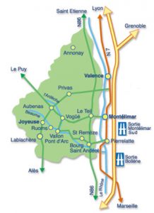
4 hours from Paris, Bourg Saint-Andéol is located on the right bank of the Rhone at 1:30 of the Mediterranean Sea and less than 2 hours from Lyon.
The nearest train station is Pierrelatte (10 km). 20 minutes from the motorway exit 19, Bollène and toll Montélimar south.
How to get there ?
The easiest way is to use the google maps application by entering “Mas Saint Antoine” or by clicking the following link:
https://g.page/GitesMasSaintAntoine?share
if not :
A7 motorway coming from the north exit MONTELIMAR south
Highway A7 coming from the south exit BOLLENE
Take direction PIERRELATTE then BOURG ST ANDEOL
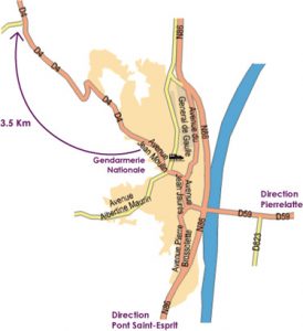
Take direction SAINT REMEZE / VALLON PONT D’ARC on the D4
4 km after Bourg saint Andéol you will see the sign “Mas Saint Antoine” it will turn there on the left.
A huge car park welcomes you under the oaks and olive trees.
On the right bank of the Rhone, at the foot of the Laoul forest, stands a city of 8000 inhabitants, with a surprising character. Old city, formerly called Bergoïata, Bergum and Bourg-Saint-Andiou, Bourg Saint-Andéol has the privilege to have the most historical monuments classified and protected in Ardèche and proudly displays the many testimonials it has preserved during the time :
– Roman bas-relief of the God Mithra (3rd century), carved in the rock.
– Dona Vierna (benefactor of the city, statue on the square of the fields of Mars)
– Romanesque church Saint-Andéol (twelfth, sixteenth and eighteenth centuries), which contains a paleochristian sarcophagus containing the remains of Saint-Andéol.
– Town hall (former Urseline convent)
– Saint-Polycarp Chapel (9th century).
– Tour of the Nicolay Hotel and Joan of Arc Tower
(Gothic style).
– The Palace of Bishops of Viviers (16th century).
– Private mansions (eighteenth century).
– Laundry near the sources of the Sunflowers
– Old neighborhoods rich in curiosities
(15 historical monuments)
– Several classified castles (12C origin)
GPS data: 44 ° 23 ‘50.2 “North – 4 ° 36’ 51.4” East


